The Severn navigation
Although Thomas Telford complained that it was too dry in droughts and too prone to flood in the rainy season, the Severn was a major transport route for millennia.

|
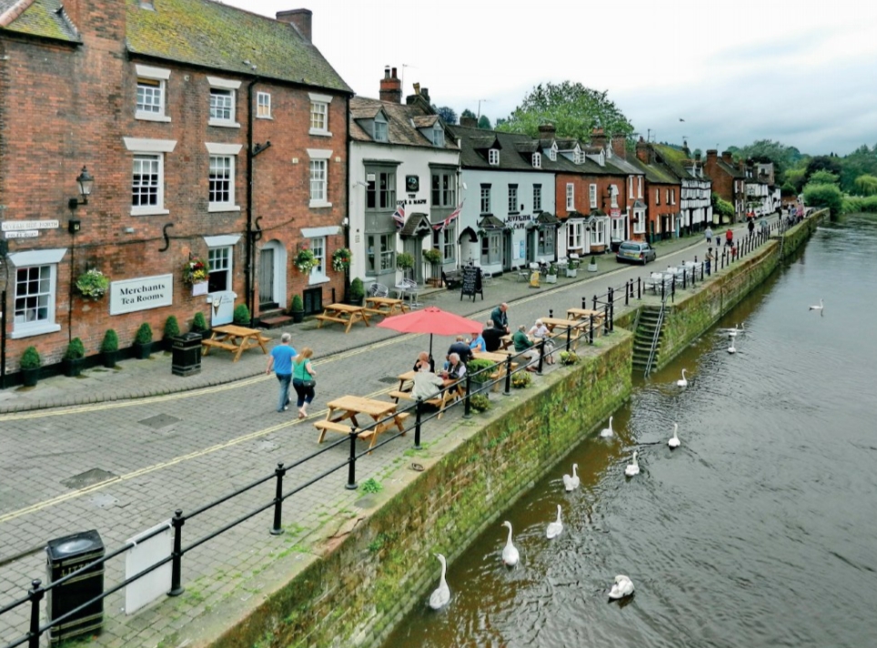
| Bewdley was one of the principal up-river ports on the Severn. (Photo: Tanya Dedyukhina, Wikimedia). |
The Severn is a young river. Before the last ice age the river ran north from Wales to the Dee. The ice blocked that route and a large lake was created in central Shropshire which, when it drained, cut the Severn Gorge past Ironbridge.
From Welshpool down past Shrewsbury to the entrance to the Gorge, the river meanders and is fairly shallow. Through the Gorge and on down to Stourport, it has a succession of pools, stretches where the water is deep and flows slowly, and riffles, where it runs rapidly across pebbly shallows, these being most concentrated in the Gorge. Through the ‘Middle Severn’, from Stourport to Gloucester, it is joined by other rivers with significant water flows, principally the Stour, Salwarpe, Teme and (Warwickshire) Avon; below Tewkesbury it is increasingly tidal. Below Gloucester the river is a winding estuary, the site of the country’s most spectacular bore at spring tides.
The Severn is prone to flooding, especially early in the year when the snows melt in central Wales. In 1797 Thomas Telford wrote that an impediment to navigating the Severn was ‘the deficiency of the water in droughts and... the superabundance of it during rainy seasons’. The problem had got worse, which he attributed to the raising of riverside embankments in Montgomeryshire and Shropshire, with the flood water no longer flowing on to washlands, then coming slowly off as the water subsided. The liability to flooding had one indirect benefit for navigation: the Severn, unlike, say, the Thames, was not suitable for the construction of watermills and their associated dams. Instead, the watermills were built on the streams which entered the river. Thus the Severn was navigable, water levels permitting, all the way up to Pool Quay, three miles short of Welshpool.
The principal man-made obstructions on the Severn were fish-weirs. Typically these comprised a wattle fence, supported by timber braces and piles, running across the river to form V-shaped funnels pointing downstream, with a bag-like net at the apex of the funnel in which to catch the fish, principally eels. Over 40 are known to have existed in Shropshire alone, although not all at the same time. The weirs either did not cross the whole width of the river or, more commonly, were bypassed by barge-gutters, some natural but many deliberately dug, which allowed the passage of fish to their spawning grounds and also permitted boats to pass. Some parish boundaries follow barge-gutters, which proves their antiquity.
The Severn has been a major transport route for millennia, analogous the M5 nowadays. There is evidence that the Romans had a harbour at Wroxeter, once the fourth largest town in Britain. The medieval cathedrals of Gloucester and Worcester and many churches used stone brought by water. Other early traffics included salt from Droitwich. Many boats from the Middle Severn traded to Bristol and ports in the Bristol Channel, although transhipping of goods at Gloucester increased during the 18th century. The principal up-river ports were Worcester, Bewdley and Shrewsbury. The various records also demonstrate the wide variety of the goods carried, including raw materials, manufactures and agricultural products, and the significance of the transit traffic to and from the midlands and north-west England. By weight, the biggest traffic was coal from the Coalbrookdale coalfield. In 1662 it was claimed that 100,000 tons of coal a year were shipped to towns along the river. Other major bulk trades included salt, timber, bricks, slates, lead, and pig iron from the Severn Gorge to forges elsewhere for converting into wrought-iron products.
Trade on the Severn increased with the building of locks on the river Avon to Stratford (1639/1666) and the opening of the Droitwich Canal (1771), Staffordshire and Worcestershire Canal (1772), Stroudwater Canal (1779, extended to the river Thames in 1789), Hereford and Gloucester Canal (1798 to Ledbury), and Worcester and Birmingham Canal (1815). Transhipment basins were developed at Worcester (Diglis) and at Stourport, a town created because of the new canal.
As a rough guide, in favourable conditions, boats loaded with 60 tons could navigate to Coalbrookdale, with 40 tons to Shrewsbury, and 20 tons to Pool Quay. The largest boats were trows (which rhymes with ‘crows’), some of which travelled to Bristol or Chepstow; smaller boats were known as barges. Many boat-owners had several boats of different sizes.
Being the ‘King’s High Stream of England’, the Severn was toll-free, but this meant that any proposals for improvement were opposed by many users. The various towns and canal companies defended their own interests vigorously and seemed unwilling to compromise. Hence improvements were piecemeal and came only after long arguments.
The first section of the river to be improved for navigation was the estuary between Sharpness and Gloucester. Planning for a ship canal, 15 feet (later increased to 18 feet) deep, which would make Gloucester an inland port, had started by 1785; the act was obtained in 1793; but land-ownership, engineering, financial and management problems meant that it was not finished until 1827. Long-distance trade was slow to develop, and some local traffic still went via the river when the tides were favourable in order to avoid tolls.
Upstream, William Jessop surveyed the river in 1784, recommending the building of 13 or 14 locks between Diglis and Coalbrookdale, and dredging and other works below Diglis. Opposition proved too great for anything to be done.
Boats travelled downstream on the current. Haulage upstream was by gangs of six or more men, often walking in the shallows, although sails could be used when the wind was favourable. Efforts to create a towpath for horses started in the 1760s, but it was not until 1799 that one was completed between Bewdley and Coalbrookdale, followed by Bewdley down to Diglis in 1804. Acts for towpaths from Coalbrookdale to Shrewsbury and from Diglis to near Gloucester were passed in 1809 and 1811 respectively. Towing by steam-boat started between Gloucester and Worcester in 1830.
Following proposals, protracted arguments and negotiations, in 1842 an act was passed to create a body of commissioners representing towns and business interests in order to improve the river for navigation. William Cubitt, who had been appointed engineer, recommended a weir and lock at Upton, and four more between Worcester and Stourport, but that at Upton was omitted from the act. With dredging below Worcester, he thought that a depth of six feet should be achieved. The locks were completed in 1845, but dredging proved difficult because of low water and hard marl shoals. A further lock just below Tewkesbury was added in 1858.
Trade on the river below Stourport never reached expectations, largely because the rail link between Bristol and Birmingham via Gloucester had opened in 1844. The main traffics were coal, other minerals, grain and foreign timber. In the 20th century the transport of oil became significant, although this was eventually superseded by a pipeline. Today this section of the river is only used by pleasure craft.
Above Stourport trade declined after the east Shropshire industrial area was connected to the rest of the country by canal (1835) and railway (1849). The final blow was the opening in 1862 of the Severn Valley Railway from Hartlebury (near Worcester) via Bewdley, Bridgnorth and the Severn Gorge to Shrewsbury. The last known commercial voyage on the Shropshire portion was in 1895 when the barge Harry, loaded with firebricks, sank after hitting Bridgnorth bridge. Apart from trip boats which have plied at Ironbridge and Shrewsbury, the river north of Stourport has not been used by motorised pleasure boats.
This article originally appeared in Context 170, published by the Institute of Historic Building Conservation (IHBC) in December 2021. It was written by Peter Brown, the member of the council of the Canal and River Trust nominated by the Railway and Canal Historical Society (2012–19). He is the author of The Shropshire Union Canal: from the Mersey to the Midlands and Mid- Wales, which won the Association for Industrial Archaeology’s Book of the Year award in 2019.
--Institute of Historic Building Conservation
Related articles on Designing Buildings
- Abraham Darby III.
- Civil Engineering during the Industrial Revolution in Britain.
- Conservation.
- Experiencing historic towns from the River Severn.
- IHBC articles.
- Institute of Historic Building Conservation.
- Pitt Review Lessons learned from the 2007 floods.
- River.
- The conservation of historic transport infrastructure.
- The heritage of the lock islands.
- The Iron Bridge.
- Two Men in a Boat: rowing two rivers.
IHBC NewsBlog
Purcell’s guidance on RAAC for Listed Buildings in England & Wales
The guidance specifically focuses on Reinforced Autoclaved Aerated Concrete (RAAC) in listed buildings.
IHBC Membership Journal Context - Latest Issue on 'Hadrian's Wall' Published
The issue includes takes on the wall 'end-to-end' including 'the man who saved it'.
Heritage Building Retrofit Toolkit developed by City of London and Purcell
The toolkit is designed to provide clear and actionable guidance for owners, occupiers and caretakers of historic and listed buildings.
70 countries sign Declaration de Chaillot at Buildings & Climate Global Forum
The declaration is a foundational document enabling progress towards a ‘rapid, fair, and effective transition of the buildings sector’
Bookings open for IHBC Annual School 12-15 June 2024
Theme: Place and Building Care - Finance, Policy and People in Conservation Practice
Rare Sliding Canal Bridge in the UK gets a Major Update
A moveable rail bridge over the Stainforth and Keadby Canal in the Midlands in England has been completely overhauled.
'Restoration and Renewal: Developing the strategic case' Published
The House of Commons Library has published the research briefing, outlining the different options for the Palace of Westminster.
Brum’s Broad Street skyscraper plans approved with unusual rule for residents
A report by a council officer says that the development would provide for a mix of accommodation in a ‘high quality, secure environment...
English Housing Survey 2022 to 2023
Initial findings from the English Housing Survey 2022 to 2023 have been published.
Audit Wales research report: Sustainable development?
A new report from Audit Wales examines how Welsh Councils are supporting repurposing and regeneration of vacant properties and brownfield sites.


